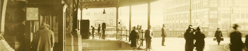
This week we go back to the park theme and head to Hyde Park, Sydney. Just look at that traffic, or lack of! Today, people still relax in the park for their lunch break, however the trams are long gone.
We have a slight head start with this photo as St Marys Cathedral is in the background and an historical timeline is available on the St Marys Cathedral website. Can you help us to date this photo?

We have many other undated photographs in Photo Investigator and on our Flickr account. If you know the dates or any other interesting facts about these images please let us know.
Category: -- Can you date...?
Robert Mills says:
Well lets start the discussion rolling with some of the transport elements present in the image:
There appears to be an O class tram operating along Elizabeth St southbound followed (possibly) by an F class tram. O class trams were introduced from 1908 onwards and the F is an early electric type. I dont have access to Flicker so cant be sure of vehicle classes.
The large ornate wooden waiting shelter dates back to the steam tram era and was built in the 1890s. This particluar example was later moved to Maroubra Beach tram terminus in the 1920s (It is still located there now in 2011).
There is no evidence of the City railway extension in progress. So its not post WW1.
The trams are electrified so the image must postdate the Federation era when the eastern lines were being electrified.
So … we have a time window of c1908 to outbreak of WW1 most likely and certainly not in the 1920s when Bradfields efforts become evident in Hyde Park.
The date of provision of the elevated signal box could be obtained from David Keenan’s book on the ‘City Lines’. I suspect it was there from the turn of the century if not earlier as tram movements were intense along this corridor well before 1900 as George St was denied to tramway operation until the advent of electric operation.
The landscaping arrangement in the park may also be a clue. There is no low stone wall along Liverpool St frontage …
There’s a start for debate !
Robert Mills says:
One further thought … the crush load passenger capacity of the 2 trams present in this image would be the equivalent of hundreds of single occupant cars – highlighting the fact that cars consume space at a prodigious rate and public transport is spatially efficient and requires no parking space ….
JennysOldCars says:
So this photo is looking northward down Elizabeth Street.
In the middle ground, on Elizabeth Street, after the 2 southbound trams is a small car. It is very difficult to determine too much about it but I’ll take a stab that it’s a light car of the pre-WW1 era.
Little cars – in the form of voiturettes, cycle or light cars are really nothing new. They were around in one form or another especially in the veteran and vintage years, sometimes from major manufacturers like Peugeot, Bugatti, Morgan….. or as 1 off-home builds, with small, light frames and bodies with smaller capacity engines, often motorcycle in the case of cycle cars. There were dedicated manufacturers who produced into the 1920s in the USA – Briggs & Stratton Flyer, Auto Red Bug and.
The popularity of the light or cycle cars was as economical transport and/or for motor sport, their production heyday was really in the 1910-1916 period – though the ubiquitous Austin 7 ran from 1922-1939. Competition from the Model T Ford, Morris and other small but still economical and family-sized cars ended demand for the light cars.
I guess the clothing styles are around WW1 era too but they not my area of expertise.
I did find out that:
•Museum Railway Station constructed 1922-26 [Heritage Council of NSW]
•The Anzac War Memorial building was started1929/1930.
Jennys Old Cars
beachcomberaustralia says:
That style of lamp post on the left was first introduced in 1912 – see http://www.cityofsydney.nsw.gov.au/history/sydneystreets/Minding_the_Streets/Lighting_Up/51_4_351.html
See note on Flickr photo
Debbie says:
251 Elizabeth Street (Dr George J Walsh signage) :
1910 – William G McClure physician & surgeon listed in Sands Directory, city streets, pg 51.
1912 – Dr George J Walsh referred to at this address.
The Sydney Morning Herald, 4 May 1912, pg 18
http://nla.gov.au/nla.news-article15334997
1913 – George J Walsh LRCP, LRCS, LM (Edin.), Physician and Surgeon listed in Sands Dir, alphabetical, pg 1627.
1915 – George J Walsh physician & surgeon listed in Sands Dir, city streets, pg 54.
1916 – George J Walsh LRCP, LRCS, LM (Edin.), Physician and Surgeon listed in Sands Dir, alphabetical, pg 1808.
1917 – Dr W McClure referred to at this address but noted that Dr Walsh’s sign was still on the bldg even though he had been dead 2 yrs.
The Brisbane Courier, 1 May 1917, pg 6
http://nla.gov.au/nla.news-article20145739
Debbie says:
The T & G building:
1889 – first 5 floors built
1913 – top 3 floors added (our photo has these)
1926 – boarding went up for demolition
(see http://www.skyscrapercity.com/showthread.php?p=33533808 with 1926 photo)
enno says:
why are these completely different comments now to the ones which were here three hours ago ??????
Debbie says:
Peterkin Chambers (233 Elizabeth Street) :
Earliest reference I can find at the moment to “Peterkin Chambers” is an advert in SMH 20 Jun 1914 for Charles Pettitt, Surgeon Dentist.
In the 1914 Sydney Assessment Books for Macquarie ward, owner is Charles J Peterkin. Charles J Peterkin was a chemist.
Became Peterkin Private Hotel (found adverts c1927-1930)
Became Ritz Hotel – (found adverts c1936-1937)
Anthea Brown says:
A great start and a rough date range of c.1908-pre WWI, @RobertMills, thank you! If it helps, I think you can access the larger version on Flickr without having to have an account.
That’s interesting to know how structures such as the shelter used to be moved and re-used.
@JennyOldCars I like the idea of moving around the city in a voiturette! No sign of Museum station here so definitely pre-1922.
@beachcomberaustralia good spot with the lamp post – that moves the start date up a few years from c.1908 to 1912.
@Debbie Impressive use of the Sands Directory and the signage for Dr Walsh being at 251 Elizabeth Street from 1912 ties in with @beachomberaustralia’s lamp post dating technique.
@enno not sure what you mean about the comments. Everything looks OK from this end this morning.
enno says:
There is a separate collection of comments for this photo at Flickr, thats why I got confused.
Debbie says:
Our photo is dated 1912 at:
ArchivePix
City of Sydney Archives digital photograph bank
http://www3.photosau.com/cos1/scripts/home.asp
“Corner of Elizabeth Street and Liverpool Street”
File: 04444651
Len Stone / Vic Solomons Collection: 97
They also have some wonderful photos of “Elizabeth Street Widening” 1909.
Including:
File: 00101777 (looking back the other way from around the spot of our photo)
File: 00101778 (taken from cnr Elizabeth & Liverpool – same direction as our photo but from ground)
beachcomberaustralia says:
Re- Peterkin Chambers (as mentioned by Debbie above) – there is a description of the NEW BUILDING (including rubber floors imported from New York !) in the SMH 12/5/1914 para 2 – http://trove.nla.gov.au/ndp/del/article/15507096 .
The same article mentions road widening activities, and I think that is the main purpose of this photo.
So after mid-1914 so far?
Debbie says:
@beachcomberaustralia – yeah, the City of Sydney Archives date is not right. I’m at mid 1914 to 25 Feb 1916 (maybe even 1915) now. See below re T&G bldg:
‘…Temperance and General Mutual Life Society Limited has erected and remodelled an extensive palatial building,…’
Sydney Morning Herald, 25 Feb 1916, pg 6
http://nla.gov.au/nla.news-article15668030
I also found this:
‘Completed in 1915, its Sydney offices also housed shops and professional suites, while the upper floors were devoted to flats.’
“The Way We Were”
Sydney Morning Herald, 19 May 2007
Caroline Butler-Bowdon and Charles Pickett
http://www.dentalsurgeons.com.au/news/2007/5/19/the-way-we-were/
The person on skyscrapercity.com (in one of my prev messages) seems to be in error. The photo of the old T&G bldg he refers to as being before demolition in 1926 is at ArchivePix and is dated 20 Mar 1928. See:
T & G Mutual Life Building
File: 00101619
RECORDSERIES: NSCA CRS 51, Demolition books, 1900-1949
The start of T&G’s 2nd bldg:
10 Dec 1927 – council has part claimed for Park street widening (SMH 10 Dec 1927 pg 19).
See article & photo SMH 19 Jan 1932 pg 4 for further dates of demolition & completion – bldg was done in 2 sections with tenants remaining).
They then had the 3rd bldg in Bligh street.
Debbie says:
Sorry, I phrased those dates incorrectly in my last post – I mean “from” those dates not in between those dates.
Debbie says:
T&G building is under construction in 1914 so the 1915 date from SMH 2007 looks right:
“The Growing City”
The Sydney Morning Herald, 15 Dec 1914, pg 8
http://nla.gov.au/nla.news-article15555090
Debbie says:
Same view as our photo & oh so much clearer :)
Museum railway station (Liverpool Street) construction by By Bradfield, JJC, 23 Oct 1922 at State Library NSW
Spam filter is stopping me posting the link so go to State Library website & search.
I found it firstly at:
http://www.dictionaryofsydney.org/place/hyde_park
So is our photo the “before” photo of the Hyde Park railway construction work?
Work began in Hyde Park in 1919 with the felling of the fig trees… treeshttp://www.dictionaryofsydney.org/item/385
Comparing our photo with the 1922 one, there is no Lessey’s building in ours. This is the same address as Dr Walsh bldg – 251 Elizabeth St, but bldg has had a floor added etc or totally rebuilt.
26 Jul 1917 – Lessey’s Motor Auction rooms are at 135 Castlereagh Street (advert).
22 Nov 1917 – Lessey’s Auto Sale Room 189-193 Elizabeth street (advert).
1921 – Lessey Salerooms at 189/193 Elizabeth Street, rated:B S Lessey, owner/landlord: Estate late John Taylor (Assessment Books City of Sydney Archives).
1921 – Metallurgical works at 251 Elizabeth Street, a 2 floor bldg listed, person rated: AW Dye, owner/landlord: children Thomas E Rofe (Assessment Books City of Sydney Archives). Nothing is listed for no.253.
c1917-1939 – Lessey’s Auto Sale Room 251-253 Elizabeth Street on map (Sydney Fire Underwriter’s plans c1917-1939).
12 Aug 1922 – advert for Lessey’s at no.251-253.
So between 1921 & 12 Aug 1922 the building at 251 changed & became Lessey’s.
Could the entry on 7 Nov 1921 for 251 Elizabeth Street, lodged by Kell & Rigby be referring to this? (see City of Sydney Archives, Planning Street Cards)
http://www.cityofsydney.nsw.gov.au/
Debbie says:
re Hyde Park
‘Along part of the Elizabeth-street frontage the southern half is badly disfigured by the fences and the miscellaneous collection of materials placed there in connection with the city railway project.’
Sydney Morning Herald, 27 Sep 1919, pg 19
http://nla.gov.au/nla.news-article15846053
So unless I have confused myself (a good chance :P), our photo is between 1915 and 27 Sep 1919.
Debbie says:
Where exactly were the military buildings of the Central Recruiting Depot on the cnr of Elizabeth & Liverpool Streets (Hyde Park) ? They were also used for an inoculation depot and were apparently “very ugly structures” !! A 1918 article states that this portion of land was previously taken over by the city railway. A 1920 article talks about land that bordered Liverpool and Elizabeth streets. IF they should be seen in the area of our photo we can knock our end date back a bit further.
A few dates from Sydney Morning Herald articles:
(sorry spam filter not allowing me to post their links – I’ll email to Anthea & maybe she can edit them in < -- Done, Debbie! AB) 11 Apr 1918 - recruiting depot proposed http://nla.gov.au/nla.news-article15779887
29 Apr 1918 – ‘… At the new recruiting site in Hyde Park, similar methods and construction will be adopted…’
http://nla.gov.au/nla.news-article15773914
10 May 1918 – the recruiting depot has removed from Victoria Barracks, and is now established at the cnr of Liverpool & Elizabeth streets.
http://nla.gov.au/nla.news-article15763536
20 May 1918 – busiest military centre in NSW
http://nla.gov.au/nla.news-article15763899
11 Jun 1919 – “very ugly structures”
http://nla.gov.au/nla.news-article15850913
3 Feb 1920 – Repeated suggestions for re-use of land which once was city railways, recruiting depot & inoculation depot.
http://nla.gov.au/nla.news-article15883868
22 May 1929 – Dr. Bradfield has promised that the “depot” will be removed when the Town Hall station is finished…
http://nla.gov.au/nla.news-article16558762
So early May 1918 the recruitment depot buildings were there. Depending on what if anything was to the right of our photo, perhaps it could be dated between 1915 & early May 1818?
Pingback/Trackback
Hyde Park, Sydney | Look what I saw