A Moment in Time………….
This fortnight’s “Can you date?” post is brought to you by Jillian Kohlhagen and June Dietrich from CSU Regional Archives. They have not one but three connected photographs they are trying to place.
The three attached photos are from a collection of records belonging to the Fitzpatrick family. We’re very sure that the places in them are not around here (Wagga Wagga, NSW); plus, they look “cityish”, so maybe with a wider audience, we will have a better chance of someone identifying them. We don’t know anything about the photos (eg. where, when, etc.) or even who was responsible for taking the photos, but they have been developed onto very thin paper which makes me wonder if they were a home-job.
The first Fitzpatrick of the family was Thomas J. Fitzpatrick. He was a member of the Legislative Assembly for Murrumbidgee from 1894 to 1904 and he owned Erin Vale Estate, a property of aprox. 17,000 acres situated halfway between Temora and Junee.
Photograph 1
 - CSURA Fitzpatrick Family")
Photograph 2
 - CSURA Fitzpatrick Family")
Photograph 3
")
N.B. The Flickr account used here is a temporary one to provide access to larger versions of the photographs in this post as they are from outside State Records collection.
Bob Meade says:
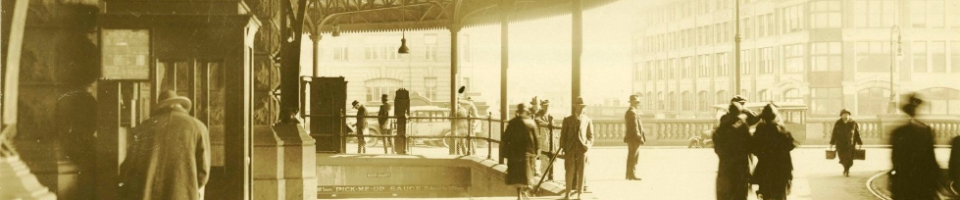
Photograph 1 is taken from above what is now named Waverton Railway Station looking south across Berry’s Bay to the City of Sydney.
Waverton Railway Station used to be called Bay Road Station, but I don’t know when the name changed.
Here is the Google maps view. On satellite photograph the structure over the railway line still looks similar, and the topography is the same.
http://maps.google.com.au/maps?hl=en&client=firefox-a&channel=s&q=bay+road+waverton&ie=UTF8&hq=&hnear=Bay+Rd,+Waverton+New+South+Wales+2060&ll=-33.837663,151.197474&spn=0.001613,0.002411&t=h&z=19
The State Library of NSW has a photograph in low resolution titled ” Suburban passenger train at Bay Road Station, Nth Sydney ” which is from the Governement Printing Office, so perhaps it is in the SRNSW collection too. The view is very similar, taken from the side of the station buildings closer to the city.
I don’t know if this link will work to the SLNSW:
http://acms.sl.nsw.gov.au/item/itemDetailPaged.aspx?itemID=184320#
The G.P.O. clock tower can also be seen in photograph 1 on the horizon, right hand side about 1/8 of the distance in from the right margin.
Bob Meade says:
Photograph 2. has what is almost certainly a railway line running across the photograph from left to right (or right to left).
The ballast upon which railway lines are bedded is visible along that line, and tumbling down the side of the escarpment in places.
John Graham says:
I believe photograph 2 is somewhere in the McMahon’s Point area, when the North Shore railway line from Waverton terminated at Milson’s Point prior to the building of North Sydney station and the SHB.
Melissa says:
Further to Bob’s earlier comment, Bay Road Station (now called Waverton Station) first opened in 1893. According to notes from the North Shore Historic Society, the name was changed in 1929 to avoid confusion with the road leading from the Pacific Hwy to Berrys Bay (http://www.northsydney.nsw.gov.au/resources/documents/H4_WavertonStation_BallsHead.pdf).
pellethepoet says:
Well done on photograph 1 BobMeade.
Here is another view from the SLNSW of Berrys Bay taken from a vantage point further forward and to the right – ttp://acms.sl.nsw.gov.au/item/itemPopLarger.aspx?itemid=413230 – The same buildings can be made out on the foreshore of Berrys Bay. And here is another of the train line running above those same buildings – http://acms.sl.nsw.gov.au/item/itemPopLarger.aspx?itemid=413231
I certainly agree with your comment about the train line in photograph 2
Rhonda Cetta-Hoye says:
Definitely Waverton Station. During off peak, trains used to be parked there on the spur line.
The Tunnel is called Bay road tunnel and it opened
1st. May 1893. So the photo is after that date.
Blowing up the photo a clock tower can be seen on the city side, which one ? G.P.O , Town Hall or Central Railway.
S: NSW Railway Tunnel Photos
Regards Rhonda
pellethepoet says:
I’m pretty sure photograph 2 shows the same section of railway line above Berrys Bay as the 2nd photo I linked. Note the bridge.
pellethepoet says:
I think this view on Google Maps is about where photograph 2 was taken, on Munro Street
Lee says:
Photo is definitely Waverton Station. North Sydney History Walk : Federation Faces and Places says that in 1900, Bay Rd Railway Station was renamed Waverton Station. http://www.photosau.com/StantonPictures/scripts/home.asp – bingo!
I agree that picture 2 is probaly around Munro Street, on the western side of the Blues Point.
Picture 3 could possible be further round on the Western side of Balls Head.
There are probably more images on Face of North Sydney which will match. There have been Fitzpatricks living in North Sydney for some time; a former mayor & doctor.
Persica says:
Photo 1
I consulted my train-spotting colleagues and got this magisterial answer from MM:
“I went searching for a track plan of Waverton and came across the same photo. It was published in the ARHS (Australian Railway Historical Society) Bulletin of August 1959, page 116. The caption reads:
“”This interesting photograph shows Bay Road (now Waverton) station during its construction. Behind the overhead booking office, the two platform buildings and part of the down platform can be seen, as well as a van in the goods siding, with the line curving away down the grade to Milson’s Point.””
pellethepoet says:
Lee – this is the image url for the link you posted:
http://photosau.com/stantonpictureslib/jpeg/001/001365.jpg
It’s tricky to link those pesky frame script image databases!
And I was thinking the same thing about photograph 3.
pellethepoet says:
Aha, here we go – open the frame in a new window …
http://photosau.com/StantonPictures/scripts/image.asp?mode=half&doc=2&pSrch=29921
Fiona Sullivan says:
Thanks for all the great comments on this batch of photographs. I have been in contact with Jillian at CSU Regional Archives and we have both been amazed by the response. The variety of sources quoted is impressive. You have unearthed far more information about the images than we had anticipated!
Jillian Kohlhagen says:
Hi everyone.
As Fiona mentioned, I’m in awe of you all being able to recognise the places in these photos, considering the sheer size of Sydney. And to have found one of the images at a number of different places has completely changed our view on them – they’re not likely to be “holiday snaps”.
Thanks for all of your help. We’ll know where to come, if we need to ID any more images!
Lee says:
Thanks Pelle. I couldn’t open one of yours either. This photo from the Mitchell Library shows a similar terrain
http://acms.sl.nsw.gov.au/item/itemLarge.aspx?itemID=210423
Of course, Dr Ian Hoskins, Archivist of North Sydney Council & author of a recent book on Sydney Harbour, would tell you in a trice & may even be able to offer more info on the Fitzpatrick connection.
pellethepoet says:
Thanks Lee. I was trying to post the record with the image and the description you were referring to. It must have been a temporary page with a time-out. I guess there’s no way around those kind of databases except by doing a manual search. A keyword search using the image number “001365” will bring up the relevant record.
beachcomberaustralia says:
Photograph 3 has me intrigued. The landscape looks too flat for the North Shore / Lane Cove River area. I am wondering if it is somewhere like Iron Cove? Maybe Balmain or Pyrmont chimneys in the background? Those look like dredging and pile-driving steam boats making a canal.
Lee says:
I am convinced that Photo 3 is Balls Head Bay. It is an almost identical point of view to a Harold Cazneaux image used on the cover of “Down the Bay,” a North Sydney (Stanton Library) publication. I can’t find an image online. But if you go to the library’s website & click on Heritage Databases & search for “balls head bay” it will bring up some images which show a similar flat & low lying shoreline. It was previously called Kerosene Bay. That may also bring up some images.
beachcomberaustralia says:
By chance I just came across Picture 2 in State Records own collection “View of terrace houses atop a rockface” – http://investigator.records.nsw.gov.au/Entity.aspx?Path=\Image\9065&format=print
Coals to Newcastle!
Still puzzling over Picture 3 . . .
pellethepoet says:
Well spotted beachcomberaustralia. Plain sight is always the best hiding spot!
I’m still puzzling over 3 too …
pellethepoet says:
beachcomberaustralia, you were correct in your speculation on photograph 3. It is indeed Iron Cove (then Long Cove).
There is a photograph showing the same scene, from a slightly different vantage point, reproduced on page 29 of ‘Landmarks in Public Works: Engineers and their works in New South Wales, 1884-1914’ by Lenore Coltheart & Don Fraser (Sydney : Hale & Iremonger, 1897). The image is captioned: “Reclamation at Long Cove (now Iron Cove) with pontoons supporting discharge pipe from barge”.
beachcomberaustralia says:
Brilliant work pellethepoet.
I think they were reclaiming mudflats and building the 1890 Hawthorne Canal (aka as the Long Cove Canal and the Leichhardt Canal, see http://en.wikipedia.org/wiki/Hawthorne_Canal ). That would be about the same date as the other photos as the railway opened in 1893.
Map of the area in 1890 – photo taken from about the “B” of Broughton – http://www.nla.gov.au/apps/cdview?pi=nla.map-rm1280-s1-sd&rgn=0.2824756291,0.5921822099,0.3731580141,0.7152970145&prevwidth=400&cmd=zoomout&width=1200
Fiona Sullivan says:
Great work all round! Also just to let you know, the setting that was blocking comments with links from coming through has been removed (fingers crossed).
pellethepoet says:
Obviously I meant Hale & Iremonger 1987 – not 1897!
Fiona Sullivan says:
Summming up this post which I think is one of our most commented on “Can you dates?” and has great examples of detective work and teamwork in action is no small task. (Compounded by the fact that the internet has now eaten my previous versions of this comment twice!)
Photograph 1
Straight out of the gate @Bob Meade identified this photograph as Waverton/Bay Road Station. This was corroborated by @Melissa, @Lee and @Rhonda Cetta-Hoye with a diverse range of sources and information. It was established that the Bay Road Tunnel was opened on 1 May 1893, giving a rough idea of a possible time frame.
@Persica then tracked down a caption for the photo from ARHS (Australian Railway Historical Society) Bulletin of August 1959, page 116. The caption reads:
”This interesting photograph shows Bay Road (now Waverton) station during its construction. Behind the overhead booking office, the two platform buildings and part of the down platform can be seen, as well as a van in the goods siding, with the line curving away down the grade to Milson’s Point.”
Photograph 2
@PellethePoet promptly identified the location of this photograph as Munro Street looking across Berrys Bay. @Beachcomber Australia was then the source of at least one red face at Archives Outside when he located a version of this photograph in State Records own collection!
Photograph 3
This photograph proved to be the most elusive. There was a bit of debate and speculation about its possible location until a speculation of “Iron Cove” from @Beachcomber Australia led @pellethepoet to locate a similar image in a publication about public works with the caption “Reclamation at Long Cove (now Iron Cove) with pontoons supporting discharge pipe from barge”!! @Beachcomber Australia was then able to link the photograph to the building of the 1890 Hawthorne Canal.
I think this is my favourite “Can you Date?” post so far, mainly for all the twists and turns it took along the way. As Jillian has previously commented, the staff at CSURA are very grateful for all this information and most importantly it has changed the way they look at the photographs and the reason they were part of the collection they are in!
enno says:
Photo 2 is not “looking across Berrys Bay”. The photographer is down near the shore of Berrys Bay ( it is behind his back ) looking up the hill towards North Sydney.
I had some doubts about Long Cove. I would have thought the photo might be looking up the SW arm of the cove and the suburb in the background is Croydon. The silver tower of the PLC school is very distinctive from that vantage. But he is right, it is the Hawthorne canal. Its Leichhart in the background. The strange thing is, whats the deal with all the trees in Haberfield ?
santa says:
Wow these photos are really old lol. It was fun reading your blog
Shirley Colless says:
Photo 1 as already identified is Waverton Railway Station, c 1890-1893.
Photo 2 is the Waverton rail tunnel, running under King Street – taken from the northern (Wollstonecraft) side.
Photo 3 is more than likely taken from Waverton, looking west across Ball’s Head bay to what is now the Berry Island Reserve – where the original island has been linked to the mainland. The factory in the distance is probably on Greenwich Point, where the Shell Oil Refinery currently stands.