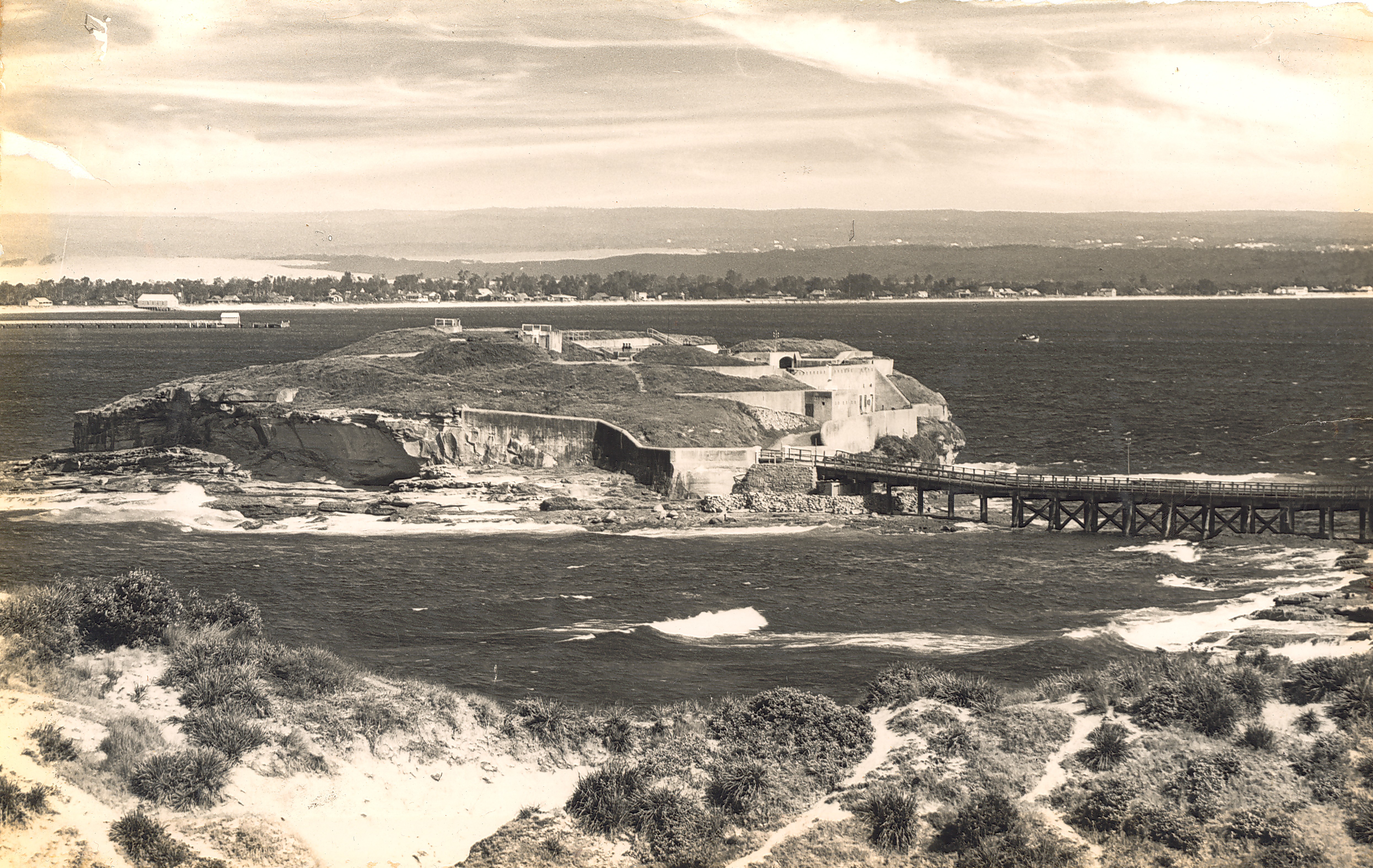
What clues can you find to date this image showing the view of Bare Island from La Perouse across Botany Bay to Kurnell?
Can you date this photograph?
We have many other undated photographs in Photo Investigator and on our Flickr account. If you know the dates or any other interesting facts about these images please let us know.
Category: General
Edgar Baltins says:
I suspect the photo was taken no earlier than the mid-1950s because the long jetty (Kurnell side) looks like the one built by Caltex when it built the oil refinery (finished 1956). The photo could be in the early 1960s as the houses (Kurnell side) are much better finished than the shanty-type housing built during the 1930s when Kurnell was referred to as “Happy Valley”. Could the photo be after 1983 when Bare Island ceased being a retirement home for war veterans: can’t tell, but couldn’t imagine photo being younger than mid-1960s.
linda necia says:
I think it might be 1900 – 1920. See this post card item in Power House Museum:
http://www.powerhousemuseum.com/collection/database/?irn=54288
I think there would have been more buildings on Brighton-le-sands side of Botany Bay if it was later maybe?
Edgar Baltins says:
Linda, your photo (which is a great photo) faces East through Botany Bay heads, whilst the Archive photo faces South-Westish with those heads not in view at all. Still think the Caltex jetty being there prevents the photo being pre-1956. Sorry
carolyn says:
I think the angle gives the impression thats its the Caltex Wharf when in fact its more likely that its the ferry wharf in the park. I think at the end of the wharf I can see two places for alighting the ferry which I remember and different sides were used according to the weather. The wharf was rebuilt to some degree a couple of times as far as I can recollect.
My family home was bought in 1945 and was in the condition pictured clearly in the photo (but was a lot different by the time the Caltex Wharf was built) The houses and empty blocks are much as I remember them as a young child. In 1945 and earlier there was a sleeper wall along some of the area west of Dampier Street which later washed away and eventually in the 60s was replaced with the rocks and groynes. I have a photo of the sleeper wall with pre 1945 written on it the house as my parents bought it and a photo of myself in about 1949 sitting on the wall. I cant see the wall in the photo. Amazing how much area the sandhills took up in the photo.
My family home was quickly added to and a windmill put in place which leads me to believe this photo is well before 1945.