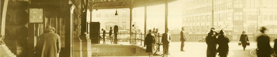
Our nations capital – Canberra!
This image shows the view from Red Hill on the south side of the city.
Can you date this photograph?

We have many other undated photographs in Photo Investigator and on our Flickr account. If know the dates or any other interesting facts about these images please let us know.
Category: -- Can you date...?
Tag: Canberra, Moments in Time
enno says:
This is a photo looking northeast over Griffith Kingston and Fyshwick, towards the airport. On the left edge of the photo is the edge of the circular Collins Park. On the left edge at the background is the military college.
enno says:
Things I can see in the photo. There is a train on the right near the current location of the railway station. I think the railway originally ran a few hundred metres further, along the side of Wentworth Avenue. This is where the continuous row of trees is, across the middle of the photo. There is a hangar at the airport.
You can see Manuka Oval and apparently the cricket scoreboard.
You can see the church beyond Manuka Oval which according to Google Maps is the Baptist Church.
Actually, the cleared circle on the left is Arthur Circle and you can’t see Collins park which is another block to the left.
enno says:
The house with three chimneys nearest the bottom left is still there. It appears to be number 9 Torres crescent.
Mugga Way is out of shot below the foreground of the photo. The nearest street running across the foreground is Wickham Cres.
enno says:
The odd looking house in the middle foreground, with 2 square wings joined at the corner is still there, 23 Mugga Way
enno says:
The house at number 9 Wickham Crescent is still there.
enno says:
There seem to have been a ridiculous number of car accidents in Arthur Circle.
enno says:
Kingston and Griffith were described as the most thickly populated suburbs in 1944. There are very few cars visible. I think this photo is around 1938, 1939. If it was later, there would be more development visible at the airport and the military college.
enno says:
The suburb of Fyshwick appears to have been originally called “Molonglo Camp”, the name Fyshwick came into use in 1928. According to the Perth Sunday times in 1929,
“As a dutiful and diligent figure merchant. Mr Wickens has been compil- ing some suggestive statistics with regard to the wildcat capital. We do not know whether the purpose ls to exhibit the Importance of the place,but let us see. In the first place, the population of the whole Federal territory, which includes the corridor down to Jervis Bay, is 8326, and fha density per square mlle is 8.87. The population ot the city-yes, they call it a city-Is 6878. The most populous district ls fyshwick with 671 men and 498 women. Presumably these are the silverfish, or silver tails, who draw their sustenance from the Federal treasury and demand all sorts of allowances for suffering exile or martyrdom In the frosty plane. Mr. Wickens gives other mathematical computations, and says the population increased by 326 in 1929, but he fails to state what they produce. Can anyone suggest the chief Industries besides gas?”
Well since Fyshwick in this photo looks like a refugee camp, I don’t think that the people who lived there were the silvertails ! Loudmouthed shock jobs like Wickens obviously hadn’t been there !
enno says:
The second-largest building visible in downtown Manuka is still there although somewhat altered. The largest white building is not there.
The large church currently extant at the corner of Manuka Circle and Furneaux street is not present in the photo.
enno says:
St Pauls Anglican church at Manuka should be visible in the middle distance near the right hand edge of the photo. It was the first Anglican church in South Canberra. The foundation stone was laid by the Governor General in 1938 and the nave was completed in 1939.
The apparent absence of this presumably conspicuous building indicates the photo was taken in or before 1938.
enno says:
The Kingston Hotel in Canberra Avenue appears to be present towards the right.
The Hotel Kingston appears to have been opened in July 1936. This would suggest that the photo was taken between 1936 and 1938.
enno says:
The swimming pool at Manuka was partly opened in December 1930 and officially opened on Australia Day 1931. The swimming pool and its surrounding buildings can be seen on the left of the cricket scoreboard, between Manuka Oval and Telopea Park.
enno says:
The park dotted with trees on the right, is Bass Gardens. The earliest reference to this park in the Canberra Times is in 1930, refers to tree-planting at this park as a job scheme for the unemployed.
They were also going to paint the big gun at the railway station. Can you see it ?
It may have been moved by the time this photo was taken, 1936-1938.
Anna Gray says:
Wow Enno – that’s an amazing set of deductions and a compelling argument for a date bewteen 1936-1938. You have well and truly got the ball rolling!
enno says:
Where are the “usual suspects” ? I am sure one of them can spot Ern O’Malley walking down the street there somewhere.
These 4+ megapixel photos are a big improvement over some of your previous scanning efforts.
Betty Bearse says:
Our family home was in Lefroy Street, Griffith, which runs off Canberra Avenue (delineated by the row of very small trees running off to the right) near the corner of the Hotel Kingston (middle of photo). Our house was completed in 1939, and as the photo shows no streets or houses in that area, I would date the photo as early 1930’s. St. Christopher’s school is visible on the left(diagonally across from the Capitol Theatre in Manuka), and church services were held in the school before the church was built on Canberra Avenue. The existing two-storey houses in Murray Crescent are clearly visible, and Captain Cook Crescent appears as a dusty track running off to the right. The Manuka shopping centre consists of the present central Arcade building, and little else. The rows of huts (top right) would have been the workmen’s camp at Causeway, near the present railway station. The Power House in Wentworth Avenue can be seen. Happy to give further details of the photo if required.
Graham Fleming says:
There are houses in Beltana Road Pialligo so the photo is post 1934 and because the trees are up a bit I would say around 1936. There are quite a few houses missing in Beltana Road so it is unlikely to be 1937 or 1938.
rex martin says:
Our family had a home in Hann St Griffith (Canberra)many years ago – i would say it was built in the late 1930’s or early 1940’s – very solid house. As Betty comments above, there seem to be no buildings (if i am looking at the photo correctly)in the area so i concur this indicates a date around mid 1930’s.
Best Regards
Rex
Joe Stewart says:
The two storey houses between Bougainville Street and Murray Crescent were built by the Department of the Interior in 1933-34 and have been listed (register) as part of the National Estate; the URL for this is:
http://www.environment.gov.au/cgi-bin/ahdb/search.pl?mode=place_detail;place_id=17323
As the houses appear to be completed (or almost) the photo must be post 1934.
My father came to Australia as a single man in 1929. He worked in Kalgoorlie, Mount Isa and, in Canberra. He was a bricklayer and told us that he had worked on the two story housed behind the Manuka shops. He returned to Scotland in about 1939 were he married. In 1950, he and his wife and four children came to Australia. We initially lived in Ginninderra, in an old farm cottage which in now in ruins but, has been listed as a heritage site, identified as “The Valley”. In 1951 we relocated to Narrabundah, into the Prefabs in 21st street. Then in 1953 we moved to O’Connor, into the “Tocumwal” in Way Street. Eventually, he was successful in the land actions and got a block of land in Curtin where he built his own home. I left Canberra in 1980 and now live in the Llower Blue Mountains bur, as you will see, I have a long association with Canberra.