UPDATE: Thanks to everyone who identified this image as NOT Post Office, Bond Street, Sydney but Customs House Building in Newcastle! These GPO images were ‘identified’ prior to their transfer to State Records – without your help some images might forever remain mislabelled.
——————————————————
A moment in time……
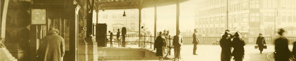
We have tested your knowledge on a number of regional NSW post offices…for a change we thought we would your help with dating an image of a Sydney post office.
No cars or people in the street…..just the time 12.55 pm.

We have many other undated photographs in Photo Investigator and on our Flickr account. If you know the dates or any other interesting facts about these images please let us know.
Category: -- Can you date...?
Robert Mills says:
Well … we have a railway freight waggon sitting at the extreme LHS of the image, telephone wires are present in the street. The building is substantial and probably reflects a product of the boom style architecture of the 1880s period.
Bond St Sydney ???? But Bond St sits between George and Pitt Sts in the City. No railway freight movements there !!
I think this image has been incorrectly titled. Chances are we are looking at a country PO. Or an alternative interpretation could be that this is a structure that once graced Darling Harbour….
What do others think ?
Robert Mills says:
Correction. This is no PO. Its the Customs House Building in Newcastle adjacent to the railway goods yards.
Robert Mills says:
This building has a long construction history. Initially opened in 1877 it was subsequently added to over time. There is reference to a dwarf wall being constructed in 1880 … so the image we have here is post that date. See
http://www.visit.heritage.nsw.gov.au/16_subnav_09_2.cfm?item_id=&itemid=5051282&sort_by=&item_name=&suburb_name=&product_category=&state_theme=&product_region=
Cheers
yewenyi says:
Here is a more recent photo taken from a little further to the photographer’s right.
http://contribute.abc.net.au/_Customs-House-Hotel-Newcastle/photo/2808799/32422.html
pellethepoet says:
According to the history at the link provided by Robert, we can further date the photo to after 1899, when the additional wing on Wattle Street was completed.
“In 1897 the decision to add an additional wing to the Custom House was made when a Royal Commission investigated management of the Hunter Board and recommended a piece of Crown land in this location be used as the site of the new offices. It was estimated a new building could be built for 4000 pounds. By the end of 1899 the new building was completed.”
There are a series of earlier photos, before the addition of the new wing, in State Records collection (the first two are printed from the same negative): 4346_a020_a020000143, 4481_a026_000538 and 4481_a026_000537 [can’t post the links – considered too “spammy”].
And there is this on Flickr by Ralph Snowball, 1900
http://www.flickr.com/photos/uon/3236947173/
Note the sign, part of which we can see at the right hand side of our image.
beachcomberaustralia says:
Well done Robert Mills! Wrong office, right street, wrong city in the title – hilarious, but too common a fault with these photos.
I am thinking this photo is after the Walter Liberty Vernon “by the end of 1899” additions to the original James Barnet building, as mentioned in the link above. I think you can see the ‘join’ in the gutter colour to the left of the telegraph pole, and more easily on Google street view. So about 1900 – it cannot be much later due to the style of the telegraph poles.
Google street view (good for comparison and a snoop round the area) – http://maps.google.com.au/maps?ie=UTF8&hq=&hnear=Sydney+New+South+Wales&ll=-32.926241,151.784881&spn=0,0.002411&z=19&layer=c&cbll=-32.926241,151.784881&panoid=a7-CwvvI4c9z1lFwLirJwQ&cbp=12,158.16,,0,-19.33
Rhonda says:
One out of three ain’t bad:) many of the GPO prints were ‘identified’ prior to transfer to State Records many years ago and we take on trust the accuracy of that identification. However mistakes are made and we are grateful that public forums allow for images to be correctly identified.
Is this now a well know drinking and dining establishment in Newcastle?
Janette Pelosi says:
Yes indeed it is Rhonda! I had a very pleasant evening dining there after a conference in Newcastle.
John Ruffels says:
Yes I agree, well done Train and Tram expert Robert Mills!
And in my opinion, Beachcomberaustralia is correct too.
The telegraph poles look to be unstrung(?).
So I would say about 1905/7.
In the ABC link photo, visible behind the Customs House, is the Great Northern Hotel, which is in Scott Street, which runs East-West.