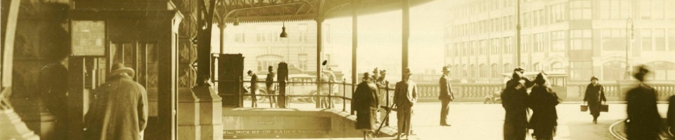
A Moment in Time……
Can you be a gem and date this image of the Saphhire City…. Inverell?

We have many other undated photographs in Photo Investigator and on our Flickr account. If you know the dates or any other interesting facts about these images please let us know.
Category: -- Can you date...?
Tag: Inverell, Moments in Time
Michael Rolph says:
Probably the mid-1940’s. This is very similar to a photo of the same scene in Elizabeth Weidemann’s book on Inverell “Holding Its Own”, described as being ‘in the late 1940’s”. Note the signpost in the foreground was apparently known as “Mick’s Monument”, named after local identity Mick O’Connor. The sign on the back of the bus at left “Biz Buzzes at Burges” is an advertisement for local ’emporium’ Burge Brothers. Moore’s barber shop (right) was in that location in 1940 as per map in “Holding Its Own”. What a great photograph, thanks for posting this!
JennysOldCars says:
Cars and buses are late 1920s to mid 1930s – could the photo be pre-WW2? I just can’t make out any late 1930s or 1940s vehicles.
Is there enough shadows for the a shadow analysis, which I find fascinating but being mathematically challenged happy to leave to our other experts?
JanT says:
I can’t get a bigger clear image, but the bus types and name of the company (if visible) might narrow it down.
Also, when did the local council start planting trees in the middle of the road? These look youngish (5 – 15 years), maybe a commemmorative avenue of some sort, perhaps the end of WW1?? Cars can set a start date, but could continue in use for years after. Can someone identify the street, business names might also help.
We think late 1920’s to mid 1930’s…
JanT says:
Out of curiosity I have just done a virtual drive along the main street, Otho Street, thanks to the wonders of Google! Looks like the photo was taken looking south -east from a first floor balcony of that old building overlooking the roundabout on Byron Street, very early afternoon, to judge by the shadows. The roof line above the Chemist and the building further down on the right are almost unchanged. The hotel seems to have lost it’s deep verandah and become retail outlets??
By the way, I seem to recall reading there was some regulation in the late twenties? that verandah posts should be phased out (‘elf’n’safety’?? ) and the canopies supported by overhead fixtures to the building – does anyone know about this – might be great for future dating. Apologies to all if I’m barking up/down the wrong street.. But anyway, who was Otho?? cheers, all, jan
beachcomberaustralia says:
@ JanT – it is indeed Otho Street from Byron Street. See note identifying ‘Grove House’ and comment over on Flickr.
I’m betting on c.1938 like many of these railway carriage photos. Anyone know who Otho was?
Anna Gray says:
This is a really great start.
Thanks for identifying more exactly the location of this image!
I’ve updated the caption in Flickr and replaced the existing Flickr image with a larger version – so hopefully that might help in identifying some business names along the street!
Vee says:
thanks Anna for the clearer pic! Showed my dad who’s an old car buff, and he said there are lots of 1920’s cars pictured, but the car on the fore right under the hotel sign is a 1936 Ford V8. He also suggested looking in to when rear to curb parking was brought in. So looks like during or post 1936.
beachcomberaustralia says:
Interesting to compare with this 1939 photo – http://acms.sl.nsw.gov.au/item/itemDetailPaged.aspx?itemID=199556#
Mick Reed says:
The number plates are two letters and three numbers I think, so 1937 or later.
Shadows – midsummer mid-day-ish. Ain’t got time to do more right now.
I’ll ‘ave a look in the archives tomorrow.
Cheers
Mick
Vee says:
that’s an interesting pic beachcomber which made me look at the Hotel Inverell more closely. The photo we are trying to date shows an empty site between the Hotel and the chemist. Your photo shows that site built on as done another shot in this historical source ( Inverell tourist info) http://www.inverell.com.au/index.php?option=com_content&view=article&id=91:inverell-history&Itemid=61, which also lists 1937 as the date of the Inverell Hotel Extension….so this shot must be 1936/37 I think
Vee says:
Sorry I probably didn’t make myself clear as it was late last night I last posted! In that link you can click on Buildings In CBD, scroll down to Otho St and you’ll see Hotel Inverell takes up 1-5 Otho St and was built in 1914, opposite is the Imperial Hotel ( 1889 6-10 Otho St ), then back across to 11 -15 is the Inverell Hotel Extension built 1937. So our photo would have to be prior Dec 1937. Unfortunately we don’t know when in 1937 the extension was finished…but maybe that’s just being picky!
Vee says:
quick trove search shows tenders were closing in June for alterations/extensions to Hotel Inverell. And as a quirky postscript…town looks really busy in this photo..lots of cars and full bus…maybe the annual April Picnic Races…or during the same month there were quite a few political meetings for an upcoming election..all the hotels were full!
Anna Gray says:
Looks like a pretty good argument mounting for a 1936-37 date!
JennysOldCars says:
Anna that larger photo seems much better to my eyes – I can now see most of the cars in it and there’s nothing there I’d pick for after 1937. In fact there’s only 6 1930s cars in the photo, detectable by their distinctive rounder turrets and in-filling of their mudguards.
Was leaving it for someone else to pick the Ford V8 as it’s an easy one for those getting into car-spotting – 1936 was the last year for headlights mounted on, not in, the guards for Ford.
The buses are 1930s but without a front view hard to pick as coach bodies were sometimes moved onto newer chassis.
Vee says:
fascinating to get your car tips…thanks……is it jenny?
Mick Reed says:
The town’s no busier than it is in several other photos of the same period that we have here in Armidale, so it doesn’t necessarily follow that some big event was on.
It could be the day for the cockies to come to town. These days it’s Friday – at least round here. Don’t know if it was then.
Crossley’s didn’t move into the chemist shop until 1935 and the Imperial Hotel on the left was rebuilt in 1940, so that’s the boundaries set. Not sure when the Inverell Hotel’s extension was finished. There are photos showing it finished, but I can’t get an exact fix on the dates.
No longer sure about the number plates. They might have two numbers followed by three numbers rather than two letters and three numbers. If any one can figure that out it’ll narrow the time range further. The new plates came in in May 1937.
The shadows are so short that it must be mid-summer and midday. Say late November to early February. 11 am to 1pm. The sun is so close to overhead that it’ll be hard to get a precise date.
Cheers
Mick
Mick Reed says:
Just found a State Library pic of similar scene allegedly taken in July 1939. Poor quality, but it shows the hotel extension finished (I think). See here:
http://www.pictureaustralia.org/apps/pictureaustralia?action=PADisplay&mode=display&rs=resultset-2555171&no=12
The shadows are much longer as you’d expect in mid-winter. Probably taken about 2pm from the shadow direction. Still plenty of parked cars.
Mick
beachcomberaustralia says:
Yes, from those short shadows it has to be midday near the summer solstice (22 Dec), in 1936/1937. I wonder if it is January 1937, due to the lack of Christmas decorations in the streets ?!
Anna Gray says:
Glad the larger image was useful!
Still sounds like we’re barracking for 1936-37 date but narrowing it down to a late 1936 early 1937…We’ll see if any more ideas develop over the next week!
Mick Reed says:
A couple of people asked who Otho was.
No one really knows. The local theory is that he was the cook on an exploration party that set up camp there. Don’t know how they know that.
Streets were named in the Surveyor-General’s office, at least up to the 1850s. Not sure when that changed.
Now Otho was a mate of Tancredi in Torquato Tasso’s poem ‘Jerusalem Delivered’. Sir Thomas Mitchell read, wrote, and was very knowledgeable about poetry and his daughter Blanche was a fan of Tasso’s poem, so presumably Dad had a copy of the volume.
I am sure Mitchell named the early streets in Armidale and we have a Tancredi Street here, so any Otho Street in Inverell could come from the same source.
Only problem is that Mitchell was dead by the time the Inverell streets were set out.
Cheers
Mick
PeterL says:
Just FYI – doens’t change the dating conclusions; JanT remarked about the trees looking “youngish” but these are native kurrajongs (Brachychiton populneum), a close relative of bottle trees and are quite slow growing. They were commonly planted in country towns as the foliage can be cut for fodder during droughts and keep stock alive.